On an expedition to northern Greenland that included researchers from the University of Copenhagen, the group unexpectedly discovered an island that turns out to be the most northerly island on Earth. In principle, the discovery extends the territory of Greenland and the Danish Commonwealth.
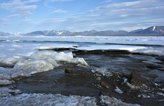
University of Copenhagen researchers were somewhat shocked when, during a major expedition in July, they visited what they believed was the world's northernmost island - Oodaaq. They were in northern Greenland to collect samples from the very extreme and remote environment found along its periphery. Instead, they wound up on a newer island even further north. The yet-to-be-named island is 780 meters north of Oodaaq, an island off Cape Morris Jesup, the northernmost point of Greenland and one of the most northerly points of land on Earth. The newly discovered and unnamed island is about 30 by 60 meters in size and rises to about three to four meters above sea level.
"We were convinced that the island we were standing on was Oodaaq, which until then was registered as the world's northernmost island. But when I posted photos of the island and its coordinates on social media, a number of American island hunters went crazy and said that it couldn't be true," explains expedition leader Morten Rasch of the University of Copenhagen's Department of Geosciences and Natural Resource Management.
A fragile expansion of the Danish Commonwealth's territory
'Island hunters' are adventurers whose hobby it is to search for unknown islands. Their comments on social media prompted Rasch and the rest of the expedition team to contact an expert at the Technical University of Denmark (DTU).
"Together with DTU, we were informed that there had been a error on my GPS which had led us to believe that we were standing on Oodaaq Island. In reality, we had discovered a new island further north, a discovery that just slightly expands the kingdom," says Morten Rasch.
This was confirmed by the GPS on the helicopter used by the group to reach the island.
According to Rasch, the island consists primarily of small mounds of silt and gravel. It may be the result of a major storm that, with the help of the sea, gradually pushed material from the seabed together until an island formed.
The island probably falls under a category known as "short-lived islets". Thus, there's no telling how permanent this fragile expansion of Greenland and the Danish Commonwealth really is.
"No one knows how long it will remain. In principle, it could disappear as soon as a powerful new storm hits," he says.